
What are Cloud Mass Meridional Transport events?
Cloud Mass Meridional Transport events (CMMTs) are defined as synoptic scale poleward propagating masses of clouds that make landfall over the mainland Antarctic continent for more than 48 consecutive hours (Staude, 2007; Chambers et al., 2026 [in preparation]). Much of the heat and moisture required for larger precipitation events over Antarctica start from disturbances in the tropics and move poleward over the span of days to weeks. These events are observed by combining geostationary and polar orbiting data within Man computer Interactive Data Access System (McIDAS) software into a single South Pole Stereographic projected image (Kohrs et al., 2014). These images are further modified in McIDAS by applying a First Regional Observing Study of the Troposphere (FROST) enhancement that emphasizes colder cloud top temperatures (Turner et al., 1996).
Guidelines for Counting CMMT Events:
- 48+ consecutive hours making landfall.
- The cloud mass is vertically developed (i.e., cumulus, cumulonimbus).
- It must move approximately 200 kilometers inland from the coastline.
- No more than 12 hours of inactivity before being classified as another event.
- New cloud masses can reinforce an existing event should they make landfall near the existing event within 12 hours of the first sign of inactivity.
- A CMMT may split into two parts. It will remain as one event until a distinct separation is observed – where the divergent cloud mass begins to be tracked. The cloud mass propagating in the original direction of the system is considered as the ongoing event.
- An event that starts in one month and ends in another is only counted in the starting month.
- A CMMT is called a “skirting event” when it zonally propagates into two or more regions while meeting all the other criteria listed above.
- Skirting events are broken into two categories: West Antarctic Skirting events (WAS) and East Antarctic Skirting events (EAS).
Project Objective
Satellite imagery is used to identify the location, frequency, and duration of CMMTs over Antarctica, especially in the absence of sufficient data for reanalyses. This offers a real-world way to verify data derived from numerical and theoretical based methods.
Human safety is also at the forefront of this project. Low cloud ceilings and hazardous weather conditions over Antarctica can pose significant challenges for aviation and field operations. These data will potentially help improve the forecasting capabilities in Antarctica and lead to safer operating conditions.
Relationship to ARs and Polar Lows
CMMTs are potentially a broad superset of poleward propagating systems that make landfall over Antarctica. Although no studies have been conducted to explore this connection, there may be a relationship between CMMTs and systems such as ARs and polar lows. Given that the size and shape of the system does not matter, more focus can be put on the heat and moisture of the system. This emphasizes the effect of a moisture-rich cloud mass on significant precipitation events over the continent.
Diagnostic Variables and Reanalyses
Eddy kinetic energy, vertically integrated water vapor transport, and moisture flux convergence are a few of the many variables that can be utilized by reanalyses and weather forecasting models (i.e., ECMWF Reanalysis v5 [ERA5], Antarctic Weather Research and Forecasting Mesoscale Prediction System [AMPS], etc.). These variables are used to match the location and time of CMMTs between satellite observations and theoretical models. The overarching goal of this is to ensure that model outputs are accurately depicting the atmospheric state of Antarctica.
Example CMMT event (Video)
The videos display content from 01 Jan 2022, 00 UTC – 03 Jan 2022, 15 UTC in the infrared (~10.8 μm) and water vapor (~6.7 μm) bands. A CMMT is visible through the entire duration of both videos around 30 °E (bottom of the video).
Antarctic Regions:
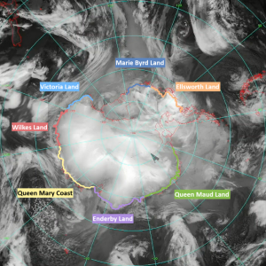
| Region | Acronym | Color | Longitudinal Bounds |
| Marie Byrd Land | MB | Dark Blue | 150° W to 120° W |
| Ellsworth Land | EL | Orange | 120° W to 75° W |
| Queen Maud Land | QU | Green | 30° W to 30° E |
| Enderby Land | EN | Purple | 30° E to 75° E |
| Queen Mary Coast | QR | Yellow | 75° E to 120° E |
| Wilkes Land | W | Red | 120° E to 150° E |
| Victoria Land | V | Light Blue | 150° E to 180° E |
Datasets and Resources
Check out the following datasets and files from the AMRDC Data Repository (ADR) for more information on this project and related polar research.
- 30-year climatological dataset of CMMTs: https://doi.org/10.48567/6ja1-8681
- Monthly text metadata documents: https://doi.org/10.48567/jjkq-qp49.
- Animations of the infrared satellite composites: https://doi.org/10.48567/y8as-0m56.
Publications/Theses related to this work
Chambers, J.M., Lazzara, M.A., Zanowski, H., Mikolajczyk, D.E., Orendorf, S., Ziegler, T., and Keller, L.M.: A 30-Year satellite based climatological dataset of Antarctic Cloud Mass Meridional Transport events, [manuscript in preparation], 2026.
Kohrs, R. A., Lazzara, M. A., Robaidek, J. O., Santek, D. A., and Knuth, S. L.: Global satellite composites — 20 years of evolution, Atmospheric Research, 135–136, 8–34, https://doi.org/10.1016/j.atmosres.2013.07.023, 2014.
Staude, J.: Poleward Propagating Weather Systems in Antarctica, M.S. thesis, Department of Atmospheric and Oceanic Sciences, University of Wisconsin-Madison, 90 pp., https://www.aos.wisc.edu/uwaosjournal/Volume4/theses/Staude.pdf, 2007.
Turner, J., Bromwich, D., Colwell, S., Dixon, S., Gibson, T., Hart, T., Heinemann, G., Hutchinson, H., Jacka, K., Leonard, S., Lieder, M., Marsh, L., Pendlebury, S., Phillpot, H., Pook, M., and Simmonds, I.: The Antarctic First Regional Observing Study of the Troposphere (FROST) Project, Bull. Amer. Meteor. Soc., 77, 2007–2032, https://doi.org/10.1175/1520-0477(1996)077%3C2007:TAFROS%3E2.0.CO;2, 1996.