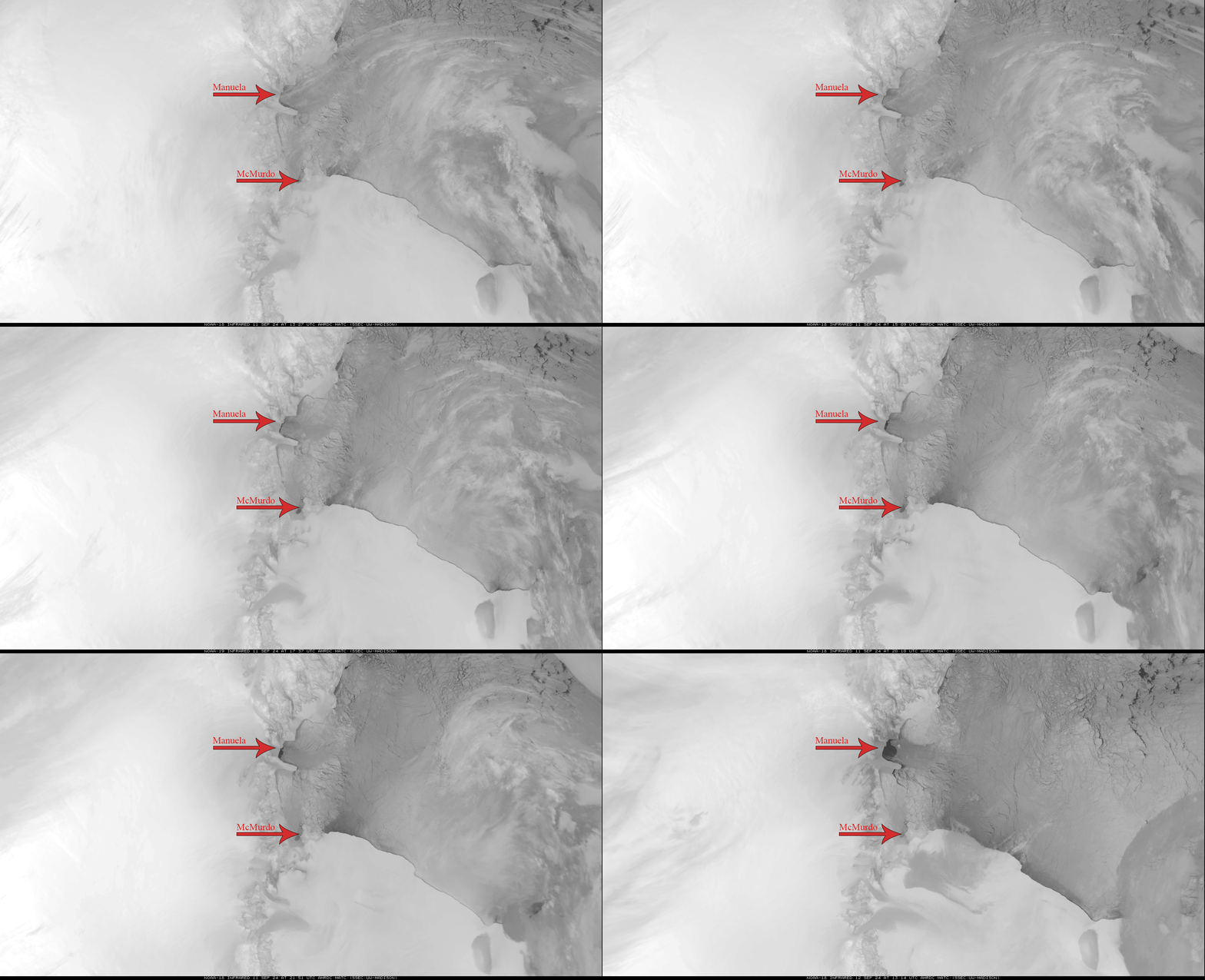
On September 11th and 12th, 2024, intense katabatic winds into the Ross Sea resulted in rapid formation of polynya up the Antarctic coast from McMurdo Station. Fortunately, in this instance of polynya, the automatic weather station (AWS) Manuela was situated on the coast where the polynya formed, allowing us to examine the wind more closely. At 1:42 UTC on September 12th, the winds peaked from the west southwest (260 degrees) at 39.1 meters per second or approximately 87 miles per hour. A Category 1 hurricane has minimum wind speeds of 74 miles per hour, meaning that hurricane force wind speeds were observed at Manuela during the peak of this event.
So, what is polynya? Polynya simply refers to open areas of water surrounded by sea ice, and is visible in Figure 1 as a growing dark spot to the right of Manuela. While the imagery is not in the visible, the contrast is still extremely apparent as the open water is warmer than the surrounding sea ice. In Antarctica, coastal polynyas are common occurrences as a result of the sometimes extreme katabatic winds. The Manuela AWS sits at an elevation of 78 meters (~256 feet) above sea level. Approximately 100 kilometers inland from Manuela, the elevation increases to 2000 meters (~6500 feet). For comparison, the distance from Madison to Milwaukee in Wisconsin is approximately 100 kilometers. Thus, there is an enormous vertical drop over a relatively short horizontal distance. Cold dense air accumulates in the interior of Antarctica and will at times begin descending, sometimes rapidly, down the mountain slopes pulled by gravity. As it moves to lower altitudes, it is compressed, resulting in a warming of the air, but it remains colder than the air it is displacing as it rushes down the mountains.
In the 24 hours prior to the peak wind observation, wind speeds exceeding 30 meters per second were first observed at 17:33 UTC on the 11th. In the intervening hours between then and the wind speed maximum, the wind never dropped below 23.3 meters per second. From this, it is apparent that the winds were not only sustained but intense.
In Figure 1, the first frame depicts 13:27 UTC on the 11th. The winds were beginning to pick up at this time with Manuela observing winds of 21.1 meters per second, but not yet reaching the hurricane force winds that would later be observed. By the final frame, the peak wind speeds had already been observed, but the winds were still exceeding 30 meters per second and would continue to do so for about the next six hours.
While there is a very dramatic jump in the size of the polynya from the second to last to the last frame, it is important to note that this is because there is an approximately 15 hour gap in satellite imagery, not necessarily because the formation of the polynya accelerated.
As a final note, the wind observations reported here were taken from real-time data from the AMRDC so the values were not quality controlled.